ISOT September 1901 - USA moves to Pacific, Canada and Mexico meet in the middle

raharris1973

Well-known member
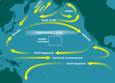
Right after the swearing in of Theodore Roosevelt as President in September 1901, the US lower 48 states and territories, and newly acquired Puerto Rico, teleports over to a big patch of land free northwest-central Pacific between Japan, Alaska and Hawaii.


Florida ends up just west of Midway island San Francisco is about 200 miles northeast of Tokyo. Puerto Rico is deposited southwest of the Hawaiian islands.

How does the US adapt to its new position fully in the Pacific, and so much closer to East Asia? How does the USA deal with Russo-Japanese tension, the decay of China and eventual revolution, and the affairs of Southeast Asia and Oceania?

How is trade and immigration affected with the US now such a further trip from Europe? More distance boosts costs, but supply relationships had been established and chain migration had become habitual.

How much does the US, which is now an easily circumnavigable island, care about an Isthmian canal? If it loses a critical mass of interest, do any other international players fill the vacuum?

What changes, if anything, with regard to Filipino counterinsurgency and governance, and what was in OTL a pro-Japanese attitude that was well disposed towards a Japanese annexation of Korea?
 

raharris1973

Well-known member
Meanwhile, where the US used to be, Canada and Alaska move south, while Latin America moves north, to make a common Canadian-Mexican border at British Columbia and Baja California. The rest of British Columbia is separated from northern Mexican states of Sonora, Chihuahua and Coahuila by only a tiny body of water.


The dotted lines are intended to show the Arctic Circle and the Tropic of Cancer relative to the moved landmasses. By moving halfway to fill the space where the USA used to be, Canada becomes *much* warmer and Mexico becomes a bit cooler. The York peninsula of Ontario is now at the latitude where Virginia used to be, and the Bahamas have moved up to be close neighbors, with Cuba not too far either.

Puerto Rico is absent from Caribbean. The US military occupation/administration over Cuba shouldn't be lasting much longer and the US government will have much less leverage over Cuba after it transitions to independence compared with OTL.

How does the new North America develop, with Canada and Latin America being such closer neighbors and no USA in the middle? Victoria, BC, and Tijuana are neighboring towns. Canada and the Caribbean Antilles are much closer to each other. Canada and Latin America remain far closer to European markets than the USA, and passenger tickets from Europe to Canada, Mexico, Cuba and South America should be quite a bit less expensive than passenger tickets to the USA.

The cooling of places in Mexico and the Greater Antilles like Cuba, Haiti, Santo Domingo, and the Bahamas should be relatively minor, bringing it in line with the southwestern and southern USA. Although we will see occassional snowfalls in the Bahamas for a change.

The country that will change the most will be Canada, with Toronto, Ottowa, and to some extent Montreal and Quebec becoming hot and humid for many months of the year, and with much more of Canada's land area now suitable for cultivation, human settlement and navigation. We should expectation a good bit of permafrost and glacial and sea ice to melt, increasing worldwide sea levels. The northwest passage should become navigable.

I imagine that Canada, Mexico, and Cuba, but especially Canada, have a great deal of potential to divert a large chunk of the vast immigration flow that would have gone to America between 1902 and 1914.
 
  • Like
Reactions: ATP

raharris1973

Well-known member
I imagine a question that comes up is whether it makes sense anymore to complete the not yet built isthmian canal through Panama anymore, for two reasons.

For one, with most of Canada and Alaska now south of the Arctic circle, the northern sea route, directly north over North of North America is navigable, at least with icebreakers to clear the way most of the year. Secondly, perhaps simpler than an isthmian canal through the mountains and jungle in Panama, the natural channel where the Colorado river passes through Mexico between Baja California and Sonora to the sea of Cortez and Pacific could possibly be easily dredged to support transit of ocean going vessels and be further extended tho meet the new extension of the Gulf go Mexico where southern Arizona used to be, through a sort of Mexicanadian managed canal project.

Here is the world map:

 
  • Like
Reactions: ATP

What's the sitch?

Well-known member
Unironically ,probably catastrophic climate changes world wide with air and ocean current changes throwing long established patterns in whack. Mass extinctions are likely, humanity will probably pull through as a whole, but I expect that many localized species adapted to specific climates will go bye bye. The resulting history would be so different there is no way I could possibly speculate.
 

Buba

A total creep
The taiga belt of Canada moves to the temperate zone, but the soils are bad. Will mass agri settlement be possible?
The steppe zone should be wetter, at least parts of it, though ...
Newfoundland would be interesting, seeing that it would move from central-north Finland to south New England weather. Population could boom :)

I don't know enough about Mexico as to comment - but could the shunting to the north adversely affect its populated parts? For Sonora to be moved to OTL south Nevada should not be much of a difference, but for Mexico Valley to Chihuahua or NM it might be.

I'm worried about South America - won't the Pampas move to the desert zone? Falkland Islands are upgraded (?) from "Iceland" to "Scotland" :)

I don't think there would be a need for ice breakers in the NW passage. For one they are too weak to clear the straits between the islands of ice anyway. You'd need a veritable armada of them.
Two - there should be no ice between the Canadian Archipelago and the Arctic Icepack, as I expect be a strong current there, from the Bering Strait to the Greenland-Baffin Island gap. So, clear sailing, in the summer at least :)

The Drake Passage should be a nicer place than OTL.

US economy slows down, due to fewer exports of farm produce and minerals (depending upon commodity undercut by Canada, South America, maybe Africa even) as well as being less attractive for European (British) investment which was fueling US growth.
Less European immigration - distance, price, more opportunities in Canada and Americas. The ":flood" becomes a "riover", I'd say. I see the USA "missing out" on several million people.
Once the US economy recovers and grows again, Europeans start coming again?
Asian immigration an even hotter issue than in OTL?
 
Last edited:

ATP

Well-known member
No need for isthmian canal.

USA - involved in Asia,not Americas.Probably help Japan in 1905,after 1917 take Siberia with them.
Less involved in WW1/or just like Japan - with exception of few infrantry corps send there/

Canada - more people,stronger England.

WW1 - last longer,Allies still win in 1919,after real victories.No stolen victory myth,no England helping germans after WW1.

No WW2 - soviets are defeated or weaker,germans not allowed to have army.
 

Buba

A total creep
The Panama Canal is indeed interesting. The USA does not need it for Navy, nor for commerce as the NW Passage is available, but there is the sunk cost fallacy. Would it sell to (quasi) private company?

Would it sell to UK? The UK could be interested. But it was somewhat neglectful of Canada, and there is the useable NW Passage, so a Canal there is not that attractive ...

Another issue - would the canal work as designed - with rainfall filling Lake Gatum and providing water for locks - at the new location? I think that it would, but what do I know :D

Now, how about a canal between the mouth of the Colorado (now dry) and the tip of the gulf separating Mexico and Canada? What's the terrain like? Or maybe @raharris1973 decides to leave a tight yet wet and inviting passage there, killing of the isthmian canal immediately?
 
Last edited:

raharris1973

Well-known member
Now, how about a canal between the mouth of the Colorado (now dry) and the tip of the gulf separating Mexico and Canada?

yeah, the Mexicanadian canal - which Porfirio Diaz would use to greatly increase the development of Baja California and Pacific coast Mexico.

the terrain right there should be low, desert-y, and flat- it is already west of the sierra madres. So if digging is needed, it should be easy. It might not be. The mouth of the Colorado might be a tight, wet channel that flows in reverse to deeper mid pacific patches that replace southern Arizona.
 

Buba

A total creep
A problem I am worried about in respect to the tight, inviting Mexicanadian canal is providing it with adequate welcoming wetness. It could be dry, with not enough moisture for smooth operation of docks.
But maybe the terrain is flat enough as to allow for a sea level canal, like the Suez thingy?

The Canadians could be very excited to have such a canal - easier to keep the immigrants out, the RCNWP shooting Mexicans fleeing poverty in the water ...
 

ATP

Well-known member
A problem I am worried about in respect to the tight, inviting Mexicanadian canal is providing it with adequate welcoming wetness. It could be dry, with not enough moisture for smooth operation of docks.
But maybe the terrain is flat enough as to allow for a sea level canal, like the Suez thingy?

The Canadians could be very excited to have such a canal - easier to keep the immigrants out, the RCNWP shooting Mexicans fleeing poverty in the water ...

Why mexicans should flee here? in OTL USA helped masons win cyvil war after 1911,here Cristeros/catholics/ would win,and since they were pro-market,there would be no poverty.
 

Buba

A total creep
The Mexicans would still be fleeing poverty and strife.
Also I was not fully serious in my post.
By 1900 Canadian Authorities were allowing Catholics - Latin or Greek Rite both - into the country.
 

ATP

Well-known member
The Mexicans would still be fleeing poverty and strife.
Also I was not fully serious in my post.
By 1900 Canadian Authorities were allowing Catholics - Latin or Greek Rite both - into the country.
i knew,that you are usually not fully serious - but the same goes for me.
Canadian would probably take any useful migrants,just like USA in OTL.
And,Mexican ruled by normal catholics would not have reason to flee.Except masons.
 

stevep

Well-known member
Well as What's the Sitch says bar continued ASB intervention there's going to be a hell of a lot of disruption, not to say devastation of the world environment. Polar bears are going to die out in Canada without ice to hunt on and you could see the entire arctic ice cap going with more access to warmer water increasing its temperature as would a lot of methane being released from the melting permafrost and possibly methane hydrates. Which could cause serious melting in Greenland as well, along with rising sea levels. This warming could be countered locally in Europe if the Gulf Stream is seriously affected so much of Europe could be either warmed or colder.

Ignoring all this for the moment or if such things are fairly minimal as others have said the US is in a different environment with much closer links to western Asia, which will heighten tension with either/both Japan and Russia. It will be largely cut off from further European or Latin migration and the hostility toward Asian migrants could see earlier restrictions on immigrants. However its already got a fairly substantial population although the colder temperatures of its more northern location could cause issues in northern states - moderated possibly by it now being the largest island in the world. Correspondingly you could see a boost in development of some southern areas - the SW probably being cooler and wetter and the SE cooler. Economic disruption will be caused by the disappearance of the Great Lakes which will also provide some new if cool land. It will have virtually totally control of any traffic through the NW passage because of its domination of the western end of it. - One other point just occurred to me is whether the deeper geology has changed and the northern US is now on the ring of fire - which could cause it some problems in terms of earthquakes etc. On the other hand does this mean the west coast is on longer on a major fault line?

Canada should overall have a big boost in its potential as a great power. While a lot of areas will be hit by changes in temperature and water supply and there are questions about the fertility of the defrosting northern lands it will have a lot more agricultural potential and mineral development, in parts of the Canadian Shield for instance should be easier. The formerly inland provinces will now have potential ports on their south coasts while the east will be affected by the loss of the St Lawrence and all the traffic it carried. It will take time because of the lower starting population and the disruption to climate, weather transport etc but Canada could end up being similar in population and economic power to the US.

Mexico is overall cooler as its pushed northwards which is likely to make the northern lands more welcoming to agriculture and probably wetter as well with access to a coastline. As others have mentioned this could cause problems for the central valley where the bulk of the population lives. How it affects Mexico's development is difficult to say although there is a danger that since many will see the change as an "act of god" it will strengthen the more reactionary elements of the population to the determent of the bulk of the population they prey on. [Not just talking about the clerics here but also their allies in the army and large landed elites who have a joint interest in keeping the bulk of the population poor, ignorant and powerless to make them easier to control.] Of course this could be an issue for the rest of the world as well and you could see a regression in many parts of the world. You could see pressure for a retreat from knowledge. :(

I think its likely that there will be an attempt at a canal to link the Atlantic and Pacific for various reasons including political prestige and the possible limitations on the northern front - which is also longer than a direct route between Europe or much of eastern Canada/Caribbean and E Asia than a canal would be.

Not sure of the impact on the continent of Latin America being shoved northwards as that's going to cause a lot of climatic changes and hence probably chaos and suffering in many areas as they seek to adjust. Not sure how accurate the world map is as Ecuador is still shown as only a little north of the equator now? There is much greater potential for traffic around cape Horn here.

One issue that hasn't been touched on is unless the ASB has intervened to prevent it you going to have to have all the undersea telegraphs between the Americas and everywhere else relaid as their all been broken.
 

Buba

A total creep
Now - with no USA on Canada's border - how long before the UK and Canada take Alaska?

@stevep - good point about Montreal. With no Great Lakes AND the York Peninsula having sea access - it will stagnate into a sleepy derelict town of druggies and failed artists.
 

stevep

Well-known member
Now - with no USA on Canada's border - how long before the UK and Canada take Alaska?

@stevep - good point about Montreal. With no Great Lakes AND the York Peninsula having sea access - it will stagnate into a sleepy derelict town of druggies and failed artists.

I can't see that happening as Alaska is internationally recognised as US territory and neither Britain nor Canada would want to clash with the US, already an industrial giant and a considerable trade partner over the issue. I think the borders between Canada and Alaska have already been agreed but if not Canada might get a bit more of the panhandle but that would be about all. Alaska by being moved south would probably be more valuable property anyway so the US would be doubly desirous of keeping hold on it, especially since its still very close to the US and even closer to the main centres of American power now.

Where you might have an issue is the removal of much US influence from Latin America. The US is both further away and no longer directly part of the American continent so its got less basis for such a policy as the Monroe Doctrine so the region is likely to be dominated by British/European trade interests for longer. After all their naturally better trade partners because their interested in the primary products that are the region's main exports at this point.
 
Last edited:

Buba

A total creep
I am half joking :)
I many ISOT scenarios quite a few posters suggest (seriously) "USA takes Canada as it is there, next door, and the UK can't do anything about it".
Here the USA is (much) less valuable to the UK and can't do anything about the UK taking Alaska if it wanted to. The USA not only does not have much of a navy but it is in the wrong Ocean to do much harm to the British ... and in the Far East the RN would be assisted by the Nihon Kaigun which - as any weeabo will assure you - is INVINCIBLE!
:)
 

raharris1973

Well-known member
However its already got a fairly substantial population although the colder temperatures of its more northern location could cause issues in northern states - moderated possibly by it now being the largest island in the world. Correspondingly you could see a boost in development of some southern areas - the SW probably being cooler and wetter and the SE cooler.

The US has not been moved north in latitude (nor moved south) - its latitude hasn't changed at all, just longitude.
 

Buba

A total creep
The US has not been moved north in latitude (nor moved south) - its latitude hasn't changed at all, just longitude.
Nevertheless there could be some interesting changes to the USA's climate zones. Montana and the Dakotas should be wetter and less continental. Oregon gets colder?

I wonder of the North Pacific Gyre could get split in two?
It certainly will be messed up ...
North_Pacific_Subtropical_Convergence_Zone.jpg
 

What's the sitch?

Well-known member
From what I understand, Antarctica became the frozenwasteland it is today due to South America seperating from it, which led it it being encircled by cold currents in perpetuity, instead of some cold getting diverted north and some warm getting diverted south. Due to the new gaps and spots that have appeared in the map as well as the presence of the US in what used to be "empty" Ocean, I expect temperature changes. That space between Mexico and Canada will likely widen and turn Canada into a new Antarctica making it even colder than before while Mexico manages to stay warm despite moving north to the currents riding its "top" instead of being forced along Canada. I suspect that Alaska is gonna get fucked as current exchange is interuppted by the USA blocking and it will completely cease to have non winter phases.
 

Users who are viewing this thread

Top