raharris1973
Well-known member
On the night of March 27th, 1866, shortly after President Johnson’s veto of the Civil Rights Act, the United States and its surrounding waters (with the exception of the Great Lakes), out to a distance of 30 miles, a depth more than a mile or two into the crust of the earth, and to a height ceiling of 5 kilometers*, extending through a bit more than half the altitude of the tropospheric atmosphere, before it reaches the the stratosphere.
However, the footprint of the missing land, water and oil does not become a vacuum, subject to immediate filling by matter and energy from the outside, because it is surrounded by a stasis field, suspending the operation of the the dimension of time within this area. No time, no motion of matter nor energy. (https://en.wikipedia.org/wiki/Stasis_(fiction))
The first beings to notice are Mexican bats and other nocturnal flying creatures colliding with the stasis field, terrestrial nocturnal animals, the occasional nighttime human traveler, and fish at sea, Westerly and northerly winds reaching near the American west coast and US northern border are deflected upwards and sideways by the stasis field.
After dawn, the human and animal residents of New Brunswick, then of Lower Canada Quebec, when looking in the direction of the American border see only a reflection of their own woods, houses and villages along the reflective surface of the stasis field. The people, dogs, and livestock that intentionally, or accidentally go right up to the reflective surface find it completely rigid, inflexible, unbreakable.
As March 28th goes on, sailors, fishermen and merchants bound for American ports find a reflection of the sea and themselves some 30 miles from any approach to the American coast, so does anyone sailing the Great Lakes,- unfortunately, many of those without the skills, and luck, to maneuver to evade the endless stasis field shipwreck and perish. As sunrise goes west, the strange phenomenon of the missing United States and the vast mirror-like replacement becomes visible to the people of western Upper Canada, Rupert’s Land, British Oregon Country/Columbia, and the residents of the currently war-torn northern Mexican states, and mariners off the former US west coast.
As news of the literal disappearance of the United States spreads up and down the Americas, and across the oceans, fear and panic spread around the globe.
Prayer houses are packed, millenarian expectations and speculations are made, omens are interpreted. Most common are calls for repentance for an assortment of sins and prayers for safety and salvation.
Yet at the same time, for most people, in most of the world, daily life must go on. People must work daily to eat daily. Even while worried the end times are near, even the higher and mightier types need to keep doing their jobs, more or less as normal, on the uncertain chance that tomorrow, and the days and weeks after that, *will* come as normal. This applies even to politicians and statesmen.
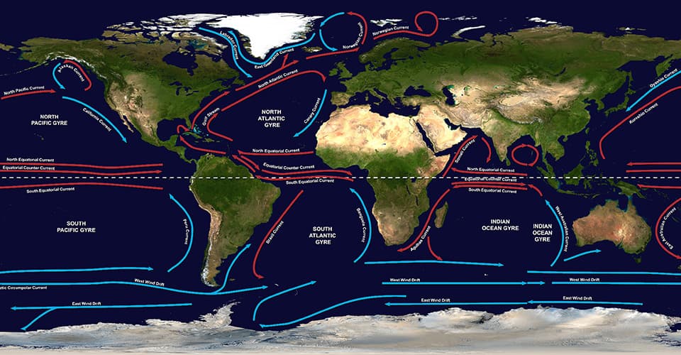
So the world in the days, weeks and months after the disappearance of America needs to deal with the real, physical, consequences of its disappearance. For the moment, broad ocean currents are similar, because the outline of the North American continent is maintained. Air currents between sea level and 5 km above sea level are blocked however, even while atmospheric currents above it flow freely. But deflection/diversion from lower levels will have some knock-on effects. Additionally, solar radiation hitting the top of the USA stasis field reflects off of it, with nearly all of it going back to space, increasing the earth’s albedo and reducing earth’s heat accumulation by a certain percentage in comparison to former daylight hours over the USA.
With over 95% of their headwaters gone, the stretches of the Colorado and Yaqui rivers dry up within an hour or so. With over 50% of its drainage basin gone, and half of its width (to the thalweg line) cut off by the stasis field, the Mexican side of the Rio Grande/Rio Bravo gets 65-75% lower. The Great Lakes, and consequently, St. Lawrence river, lose any water coming from their drainage basins in the US. This should decrease the water level of both, although the Lakes draw about as much water from Canada.
Canadian and international fishermen have the waters off New England to themselves for now, though many American deep sea fishermen and whalers, who were out to sea for multiple night deep sea fishing at the time of the event, find now they are refugees you have to lodge in the Canadian maritimes.
Some American deep sea fishermen of the south need to do the same thing in Bermuda, the Bahamas, and Cuba.
The Gulf of Mexico’s waters are no longer getting replenished and enriched from the Mississippi River system.
In Mexico, the Juarista forces who had been gaining support and momentum in their zone of control in the north, along the US border, have now lost the benefits of the border as a source of arms supplies, fresh mercenary troops, and cross-border sanctuary, in their struggle against the French-backed Imperial Mexican forces of Maximillian. At this point, the Imperial regime has superficial control over the great majority of Mexican territory, while much of the public and many generals are of uncertain loyalty, while the Juaristas have some political supporters in many parts of the country, they can only maintain a territorially controlling fighting force in Baja California, northern Sonora, northern Chihuahua, north Coahuila, and far southern Mexico around Chiapas, Campeche, and Yucatan.
The absence of the United States immediately removes American stored grains, cotton, beef, hides, iron, and all other sorts of exports from global trade and takes a relatively affluent market of 35 million people away from the exporters of Britain, Europe, the Orient, and the tropics. This should lead to a spike in the price of grain futures.
The United States is gone as a destination for aspiring emigrants, affecting people in Ireland, Germany, and Great Britain the most.
In the spirit of daily life, high and low, going on, Bismarck’s power-political scheming against Austria continues, likely still leading to Prussian war against Austria and its allies in June-July 1866, Prussian victory, dissolution of the German Confederation, and establishment of the North German Confederation, to be followed over the next year by the Austro-Hungarian Compromise or Ausgleich. The Qing Dynasty and its loyalist supporters will also still be completing their defeat of the Taiping rebels this year.
In Mexico, the French will continue to support the Imperial Mexican forces of Emperor Maximilian against the Republican forces of Juarez. With the sudden disappearance of the United States, there are no threats of intervention, although the fear of supernatural disaster sits right next door, and from the summer onward, Napoleon III’s attention ins increasingly brought back to Europe by Prussia’s remarkable victory.
Canada is spared cross-border raids by Fenian Brotherhood guerrillas based in the United States.
But...
From August 28, 1866 to September 27, 1866, unobserved by humans, further strange things happen undersea. At the bottom of the USA stasis bubble, at a steady rate, as is if 3D-printing, the “floor” of the bubble recedes, replaced with an exact copy of the Indian Ocean floor and then deep sea layers on the opposite, ‘antipodal’ side of the world. Over the course of thirty days, from the bottom of the sea, to the top, the sea is restored, with layers of Indian Ocean water joining the Pacific and Atlantic and now able to flow freely into each other, with less and less getting blocked by stasis, allowing first deep sea currents, and shallow sea currents to begin operating.
In the meantime, as if 3D printing, the subterranean layers of the continental United States from March 27th, 1866 are being reconstructed from the ocean floor upward, beneath the Indian Ocean, antipodal to their old location in the northern and Western Hemisphere. This new rising earth is kept ‘dry’ and separate from Indian Ocean waters by a thin layer of stasis no more than one micron thick.
On the night of September 27th, 1866, the whole process speeds up and completes itself, with the entire surface world of the continental United States, and all of its inhabitants, as they were at the moment of their disappearance six months before, being reconstructed in an instant, in an antipodal position to their old location, in the middle of the Indian Ocean in the eastern hemisphere, with all surfaces being the correct height from sea level.
In that same instant, the remaining stasis bubble over the old United States shrinks to infinitesimal size and then disappears entirely, allowing winds to blow, waves to form on the ocean surface, and the vast new waters where the United States used to be to be navigated.
The Americans encounter the same experiences others around the world had months earlier, finding sudden cliffs into the sea along their international borders, the volumes of certain rivers, like the Columbia, sinking, as they are disconnected from some of their drainage bases, and so on. They further find the stars are out of place and magnetic compasses are backwards from the expected in terms of north-south. However, the weather, and regional weather differences, seem seasonally appropriate. The shadows seem to fall on the landscape strangely all through March 28th.
Within a few days, an American vessel off the west coast likely makes contact with a British or French one rounding the Cape into the Indian Ocean, or an American ship from the east coast encounters a ship traveling to or from Perth, Australia, and the occupants of one ship are astounded to find that America is back, the other ship are astounded America was ever gone and that the world thinks its September, all are astounded America is in the Indian Ocean.
America, and all its productive capacity, are back in the world. Thanks to the six month delay “synchronizing” the USA to the seasons of its new hemisphere, it is spared any catastrophic disruption of growing seasons and famine.
Nevertheless, this drastic, supernatural event sparks its own wave of millenarianism in America, and a second-wave in the rest of the world, this one slightly less pessimistic but still “God-fearing” and respectful of powers beyond human understanding and control.
Among the projects of the Bureau of Freedmen and Abandoned Lands in the new American “north”, formerly its south, are several to shift landscaping to accommodate changes to the changed angle of sunlight because of the north-south switch.
As mentioned earlier, despite the disruption, people still need to earn their bread and act like the next day will come, and that makes life go on.
In the United States, a country literally turned upside down, it still means that President Johnson and the Radical Republican Congress likely still polarize against each other.
In Mexico, the French can keep up a level of commitment, and importantly, naval support, to prop up Maxmillian, and outflank the Juarez Republican forces and suppress them for the foreseeable future.
In Santo Domingo, the Spanish have worn out their welcome and face revolt. The Spanish may decide to leave, but if they do, US pressure has no part in it, because the US is not there to apply it.
Canada is under less pressure to federate without the American menace, but it faces a near term geologic menace. With the opening up of the sea of the United States, the Great Lakes, if their beds are above sea level, may drain into the sea leaving vast mud flats blocking the ports of Ontario. The draining of the Great Lakes also would halt the flow of the St. Lawrence, land locking Montreal and Quebec. Substantial works would be needed to reconnect Canada’s cities, industries and rails to the ocean, or to render land reclaimed from the sea productive.
The Russian Empire can safely assume also that the United States down in the Indian Ocean, will not be interested in purchasing Alaska.
The new geography will affect trade patterns and economics: For the remainder of the 1860s, the US location in Indian Ocean, a longer journey than the Atlantic one from Britain, France, Belgium, and the German states, provides additional protection for American industry on top of the tariff, because of additional shipping costs keeping American manufactures more price competitive. However, distance from Europe works against the competitiveness of American cotton compared to Egyptian and Mexican.
American firms start selling and making reputations in Perth, Western Australia, then Southern Australia, Victoria, New South Wales, and eventually the Cape Colony, Natal, and New Zealand, and the Dutch East Indies, India and Swahili coast.
The replacement of the old USA with a vast water passageway makes a direct Britain and Western Europe to Japan and China trade route commercially viable. It also certainly voids any interest in any Central American isthmian canals.
However, given British and French sunk costs around the Indian Ocean littorals, and in the Suez Canal project itself, and newfound American industrial competition in that area, completing the Suez Canal work is just as urgent as ever. It should be completed no later than OTL’s scheduled time of 1869.
From the beginning, with it handling a share of American trade and migration, Suez Canal receipts should be higher every year of its early decades, and while it may be stressed by bottlenecks and need maintenance, receipts should fund it. There is a chance this all could keep the Khedive of Egypt solvent, which would be a geopolitical change.
In addition to strengthening the importance of the Suez Canal, the presence of the USA in the Indian Ocean should increase the importance of the Cape Colony as a stop over in USA-European trade.
I’m going to be optimistic that the British Empire will invest at adequate scale and speed to keep Canada connected to the seas and a usable economic asset. Once it is clear this is happening, Canada should actually be a great beneficiary of the removal of the United States from its neighborhood. Canada, as one of the cheapest overseas destinations from Europe, should attract a good share of the late 1860s and 1870s immigration that in OTL was bound for the United States from northwest Europe, increasing Canada’s workforce, and speeding the settlement and development of the Canadian prairie.
Presuming the Mexican Empire can be put on a firm footing before 1870, and be put into an early version of the stability we saw with the Porfiriato of OTL, and that this can survive France’s defeat at the hands of Prussia in 1870-71, Mexico may also attract many immigrants, especially Catholic ones, who in OTL otherwise would have gone to the United States.
With a working Suez Canal and increased steamship traffic volume as the 19th century wears on, I would expect immigration to the US to resume and grow. To some extent, the existence of anchor communities like Irish in the east and Chinese in the west and Germans in the middle may distribute immigrants somewhat along OTL lines. But the new geography and shipping lanes will encourage different patterns. In general, America’s gateway for “new” European immigration should be its west coast, San Francisco and Portland, not the east. Chinese and Japanese immigrants should be no more concentrated in the west than the Gulf Coast and east. New Orleans and Galveston would be be big immigration ports.
Meanwhile, immigration from India should become substantial generations sooner, along with Indians studying in America. And Americans looking for wide open frontiers will have their choice of frontiers. They will have their own west, but there may be enough choosing to move to Western Australia to affect the local culture.
Well to do and artistic American should remain interested in Europe for cultural reasons, and should be at least as equally interested in the Far East for trade and missionary reasons, but the new geography should enhance ATL Americans interest in southern and Eastern Africa, the Middle East, India, Southeast Asia, and Australia, a great deal, while making Latin America a lost, fading memory.
Other variants of the same idea -
Version 2. What if the USA (Lower 48) disappeared in September 27th 1914, and reappeared in March 27th, 1915 - in the Indian Ocean.
The physical aspects of the scenario are identical to the 1866 scenario, except that at the very beginning of the scenario, the Great Lakes are exchanged with saltwater patches of the deep Indian Ocean, and the St. Lawrence riverbed is replaced with a deep saltwater channel from the Indian Ocean. While fouling the Lakes and River as a source of potable water for drinking or irrigation, it keeps them available for navigation constantly through the period of the stasis bubble and then after its disappearance.
How do global economics and geopolitics proceed from there?
Version 3. What if the Lower 48 USA disappeared in November 5 1938, reappeared ion May 5, 1939, in the Indian Ocean
The physical aspects of the scenario are identical to the 1866 scenario, except that at the very beginning of the scenario, the Great Lakes are exchanged with saltwater patches of the deep Indian Ocean, and the St. Lawrence riverbed is replaced with a deep saltwater channel from the Indian Ocean. While fouling the Lakes and River as a source of potable water for drinking or irrigation, it keeps them available for navigation constantly through the period of the stasis bubble and then after its disappearance.
How do global economics and geopolitics proceed from there?
Version 4. What if the Lower 48 USA disappeared in November 5 1945, reappeared ion May 5, 1946, in the Indian Ocean
The physical aspects of the scenario are identical to the 1866 scenario, except that at the very beginning of the scenario, the Great Lakes are exchanged with saltwater patches of the deep Indian Ocean, and the St. Lawrence riverbed is replaced with a deep saltwater channel from the Indian Ocean. While fouling the Lakes and River as a source of potable water for drinking or irrigation, it keeps them available for navigation constantly through the period of the stasis bubble and then after its disappearance.
How do global economics and geopolitics proceed from there?
However, the footprint of the missing land, water and oil does not become a vacuum, subject to immediate filling by matter and energy from the outside, because it is surrounded by a stasis field, suspending the operation of the the dimension of time within this area. No time, no motion of matter nor energy. (https://en.wikipedia.org/wiki/Stasis_(fiction))
The first beings to notice are Mexican bats and other nocturnal flying creatures colliding with the stasis field, terrestrial nocturnal animals, the occasional nighttime human traveler, and fish at sea, Westerly and northerly winds reaching near the American west coast and US northern border are deflected upwards and sideways by the stasis field.
After dawn, the human and animal residents of New Brunswick, then of Lower Canada Quebec, when looking in the direction of the American border see only a reflection of their own woods, houses and villages along the reflective surface of the stasis field. The people, dogs, and livestock that intentionally, or accidentally go right up to the reflective surface find it completely rigid, inflexible, unbreakable.
As March 28th goes on, sailors, fishermen and merchants bound for American ports find a reflection of the sea and themselves some 30 miles from any approach to the American coast, so does anyone sailing the Great Lakes,- unfortunately, many of those without the skills, and luck, to maneuver to evade the endless stasis field shipwreck and perish. As sunrise goes west, the strange phenomenon of the missing United States and the vast mirror-like replacement becomes visible to the people of western Upper Canada, Rupert’s Land, British Oregon Country/Columbia, and the residents of the currently war-torn northern Mexican states, and mariners off the former US west coast.
As news of the literal disappearance of the United States spreads up and down the Americas, and across the oceans, fear and panic spread around the globe.
Prayer houses are packed, millenarian expectations and speculations are made, omens are interpreted. Most common are calls for repentance for an assortment of sins and prayers for safety and salvation.
Yet at the same time, for most people, in most of the world, daily life must go on. People must work daily to eat daily. Even while worried the end times are near, even the higher and mightier types need to keep doing their jobs, more or less as normal, on the uncertain chance that tomorrow, and the days and weeks after that, *will* come as normal. This applies even to politicians and statesmen.
So the world in the days, weeks and months after the disappearance of America needs to deal with the real, physical, consequences of its disappearance. For the moment, broad ocean currents are similar, because the outline of the North American continent is maintained. Air currents between sea level and 5 km above sea level are blocked however, even while atmospheric currents above it flow freely. But deflection/diversion from lower levels will have some knock-on effects. Additionally, solar radiation hitting the top of the USA stasis field reflects off of it, with nearly all of it going back to space, increasing the earth’s albedo and reducing earth’s heat accumulation by a certain percentage in comparison to former daylight hours over the USA.
With over 95% of their headwaters gone, the stretches of the Colorado and Yaqui rivers dry up within an hour or so. With over 50% of its drainage basin gone, and half of its width (to the thalweg line) cut off by the stasis field, the Mexican side of the Rio Grande/Rio Bravo gets 65-75% lower. The Great Lakes, and consequently, St. Lawrence river, lose any water coming from their drainage basins in the US. This should decrease the water level of both, although the Lakes draw about as much water from Canada.
Canadian and international fishermen have the waters off New England to themselves for now, though many American deep sea fishermen and whalers, who were out to sea for multiple night deep sea fishing at the time of the event, find now they are refugees you have to lodge in the Canadian maritimes.
Some American deep sea fishermen of the south need to do the same thing in Bermuda, the Bahamas, and Cuba.
The Gulf of Mexico’s waters are no longer getting replenished and enriched from the Mississippi River system.
In Mexico, the Juarista forces who had been gaining support and momentum in their zone of control in the north, along the US border, have now lost the benefits of the border as a source of arms supplies, fresh mercenary troops, and cross-border sanctuary, in their struggle against the French-backed Imperial Mexican forces of Maximillian. At this point, the Imperial regime has superficial control over the great majority of Mexican territory, while much of the public and many generals are of uncertain loyalty, while the Juaristas have some political supporters in many parts of the country, they can only maintain a territorially controlling fighting force in Baja California, northern Sonora, northern Chihuahua, north Coahuila, and far southern Mexico around Chiapas, Campeche, and Yucatan.
The absence of the United States immediately removes American stored grains, cotton, beef, hides, iron, and all other sorts of exports from global trade and takes a relatively affluent market of 35 million people away from the exporters of Britain, Europe, the Orient, and the tropics. This should lead to a spike in the price of grain futures.
The United States is gone as a destination for aspiring emigrants, affecting people in Ireland, Germany, and Great Britain the most.
In the spirit of daily life, high and low, going on, Bismarck’s power-political scheming against Austria continues, likely still leading to Prussian war against Austria and its allies in June-July 1866, Prussian victory, dissolution of the German Confederation, and establishment of the North German Confederation, to be followed over the next year by the Austro-Hungarian Compromise or Ausgleich. The Qing Dynasty and its loyalist supporters will also still be completing their defeat of the Taiping rebels this year.
In Mexico, the French will continue to support the Imperial Mexican forces of Emperor Maximilian against the Republican forces of Juarez. With the sudden disappearance of the United States, there are no threats of intervention, although the fear of supernatural disaster sits right next door, and from the summer onward, Napoleon III’s attention ins increasingly brought back to Europe by Prussia’s remarkable victory.
Canada is spared cross-border raids by Fenian Brotherhood guerrillas based in the United States.
But...
From August 28, 1866 to September 27, 1866, unobserved by humans, further strange things happen undersea. At the bottom of the USA stasis bubble, at a steady rate, as is if 3D-printing, the “floor” of the bubble recedes, replaced with an exact copy of the Indian Ocean floor and then deep sea layers on the opposite, ‘antipodal’ side of the world. Over the course of thirty days, from the bottom of the sea, to the top, the sea is restored, with layers of Indian Ocean water joining the Pacific and Atlantic and now able to flow freely into each other, with less and less getting blocked by stasis, allowing first deep sea currents, and shallow sea currents to begin operating.
In the meantime, as if 3D printing, the subterranean layers of the continental United States from March 27th, 1866 are being reconstructed from the ocean floor upward, beneath the Indian Ocean, antipodal to their old location in the northern and Western Hemisphere. This new rising earth is kept ‘dry’ and separate from Indian Ocean waters by a thin layer of stasis no more than one micron thick.
On the night of September 27th, 1866, the whole process speeds up and completes itself, with the entire surface world of the continental United States, and all of its inhabitants, as they were at the moment of their disappearance six months before, being reconstructed in an instant, in an antipodal position to their old location, in the middle of the Indian Ocean in the eastern hemisphere, with all surfaces being the correct height from sea level.
In that same instant, the remaining stasis bubble over the old United States shrinks to infinitesimal size and then disappears entirely, allowing winds to blow, waves to form on the ocean surface, and the vast new waters where the United States used to be to be navigated.
The Americans encounter the same experiences others around the world had months earlier, finding sudden cliffs into the sea along their international borders, the volumes of certain rivers, like the Columbia, sinking, as they are disconnected from some of their drainage bases, and so on. They further find the stars are out of place and magnetic compasses are backwards from the expected in terms of north-south. However, the weather, and regional weather differences, seem seasonally appropriate. The shadows seem to fall on the landscape strangely all through March 28th.
Within a few days, an American vessel off the west coast likely makes contact with a British or French one rounding the Cape into the Indian Ocean, or an American ship from the east coast encounters a ship traveling to or from Perth, Australia, and the occupants of one ship are astounded to find that America is back, the other ship are astounded America was ever gone and that the world thinks its September, all are astounded America is in the Indian Ocean.
America, and all its productive capacity, are back in the world. Thanks to the six month delay “synchronizing” the USA to the seasons of its new hemisphere, it is spared any catastrophic disruption of growing seasons and famine.
Nevertheless, this drastic, supernatural event sparks its own wave of millenarianism in America, and a second-wave in the rest of the world, this one slightly less pessimistic but still “God-fearing” and respectful of powers beyond human understanding and control.
Among the projects of the Bureau of Freedmen and Abandoned Lands in the new American “north”, formerly its south, are several to shift landscaping to accommodate changes to the changed angle of sunlight because of the north-south switch.
As mentioned earlier, despite the disruption, people still need to earn their bread and act like the next day will come, and that makes life go on.
In the United States, a country literally turned upside down, it still means that President Johnson and the Radical Republican Congress likely still polarize against each other.
In Mexico, the French can keep up a level of commitment, and importantly, naval support, to prop up Maxmillian, and outflank the Juarez Republican forces and suppress them for the foreseeable future.
In Santo Domingo, the Spanish have worn out their welcome and face revolt. The Spanish may decide to leave, but if they do, US pressure has no part in it, because the US is not there to apply it.
Canada is under less pressure to federate without the American menace, but it faces a near term geologic menace. With the opening up of the sea of the United States, the Great Lakes, if their beds are above sea level, may drain into the sea leaving vast mud flats blocking the ports of Ontario. The draining of the Great Lakes also would halt the flow of the St. Lawrence, land locking Montreal and Quebec. Substantial works would be needed to reconnect Canada’s cities, industries and rails to the ocean, or to render land reclaimed from the sea productive.
The Russian Empire can safely assume also that the United States down in the Indian Ocean, will not be interested in purchasing Alaska.
The new geography will affect trade patterns and economics: For the remainder of the 1860s, the US location in Indian Ocean, a longer journey than the Atlantic one from Britain, France, Belgium, and the German states, provides additional protection for American industry on top of the tariff, because of additional shipping costs keeping American manufactures more price competitive. However, distance from Europe works against the competitiveness of American cotton compared to Egyptian and Mexican.
American firms start selling and making reputations in Perth, Western Australia, then Southern Australia, Victoria, New South Wales, and eventually the Cape Colony, Natal, and New Zealand, and the Dutch East Indies, India and Swahili coast.
The replacement of the old USA with a vast water passageway makes a direct Britain and Western Europe to Japan and China trade route commercially viable. It also certainly voids any interest in any Central American isthmian canals.
However, given British and French sunk costs around the Indian Ocean littorals, and in the Suez Canal project itself, and newfound American industrial competition in that area, completing the Suez Canal work is just as urgent as ever. It should be completed no later than OTL’s scheduled time of 1869.
From the beginning, with it handling a share of American trade and migration, Suez Canal receipts should be higher every year of its early decades, and while it may be stressed by bottlenecks and need maintenance, receipts should fund it. There is a chance this all could keep the Khedive of Egypt solvent, which would be a geopolitical change.
In addition to strengthening the importance of the Suez Canal, the presence of the USA in the Indian Ocean should increase the importance of the Cape Colony as a stop over in USA-European trade.
I’m going to be optimistic that the British Empire will invest at adequate scale and speed to keep Canada connected to the seas and a usable economic asset. Once it is clear this is happening, Canada should actually be a great beneficiary of the removal of the United States from its neighborhood. Canada, as one of the cheapest overseas destinations from Europe, should attract a good share of the late 1860s and 1870s immigration that in OTL was bound for the United States from northwest Europe, increasing Canada’s workforce, and speeding the settlement and development of the Canadian prairie.
Presuming the Mexican Empire can be put on a firm footing before 1870, and be put into an early version of the stability we saw with the Porfiriato of OTL, and that this can survive France’s defeat at the hands of Prussia in 1870-71, Mexico may also attract many immigrants, especially Catholic ones, who in OTL otherwise would have gone to the United States.
With a working Suez Canal and increased steamship traffic volume as the 19th century wears on, I would expect immigration to the US to resume and grow. To some extent, the existence of anchor communities like Irish in the east and Chinese in the west and Germans in the middle may distribute immigrants somewhat along OTL lines. But the new geography and shipping lanes will encourage different patterns. In general, America’s gateway for “new” European immigration should be its west coast, San Francisco and Portland, not the east. Chinese and Japanese immigrants should be no more concentrated in the west than the Gulf Coast and east. New Orleans and Galveston would be be big immigration ports.
Meanwhile, immigration from India should become substantial generations sooner, along with Indians studying in America. And Americans looking for wide open frontiers will have their choice of frontiers. They will have their own west, but there may be enough choosing to move to Western Australia to affect the local culture.
Well to do and artistic American should remain interested in Europe for cultural reasons, and should be at least as equally interested in the Far East for trade and missionary reasons, but the new geography should enhance ATL Americans interest in southern and Eastern Africa, the Middle East, India, Southeast Asia, and Australia, a great deal, while making Latin America a lost, fading memory.
Other variants of the same idea -
Version 2. What if the USA (Lower 48) disappeared in September 27th 1914, and reappeared in March 27th, 1915 - in the Indian Ocean.
The physical aspects of the scenario are identical to the 1866 scenario, except that at the very beginning of the scenario, the Great Lakes are exchanged with saltwater patches of the deep Indian Ocean, and the St. Lawrence riverbed is replaced with a deep saltwater channel from the Indian Ocean. While fouling the Lakes and River as a source of potable water for drinking or irrigation, it keeps them available for navigation constantly through the period of the stasis bubble and then after its disappearance.
How do global economics and geopolitics proceed from there?
Version 3. What if the Lower 48 USA disappeared in November 5 1938, reappeared ion May 5, 1939, in the Indian Ocean
The physical aspects of the scenario are identical to the 1866 scenario, except that at the very beginning of the scenario, the Great Lakes are exchanged with saltwater patches of the deep Indian Ocean, and the St. Lawrence riverbed is replaced with a deep saltwater channel from the Indian Ocean. While fouling the Lakes and River as a source of potable water for drinking or irrigation, it keeps them available for navigation constantly through the period of the stasis bubble and then after its disappearance.
How do global economics and geopolitics proceed from there?
Version 4. What if the Lower 48 USA disappeared in November 5 1945, reappeared ion May 5, 1946, in the Indian Ocean
The physical aspects of the scenario are identical to the 1866 scenario, except that at the very beginning of the scenario, the Great Lakes are exchanged with saltwater patches of the deep Indian Ocean, and the St. Lawrence riverbed is replaced with a deep saltwater channel from the Indian Ocean. While fouling the Lakes and River as a source of potable water for drinking or irrigation, it keeps them available for navigation constantly through the period of the stasis bubble and then after its disappearance.
How do global economics and geopolitics proceed from there?
")